Altamaha Riverkeeper News
ARK Weighs in Against Sea Wall on Spit
GreenLaw, on behalf of The Altamaha Riverkeeper, the Center for a Sustainable Coast and Surfrider Foundation, has weighed in with the Georgia Department of Natural Resources in opposition to the groin that Sea Island Acquisitions has proposed to build on the Sea Island Spit.
SIA wants to create a beach for potential buyers of property in an 8-lot subdivision on a sand spit that federal authorities have deemed to be too unstable as to merit federal flood protection.
The environmental coalition, relying on evaluations done by geology and shoreline experts, opposes the permit application for the 300-foot-long sea wall on grounds that it will: exacerbate erosion already accelerated by an existing groin; negatively impact nest habitat used by endangered shorebird species and logerhead turtles; negatively impact East Beach on St. Simons Island; and because Sea Island Acquisitions failed to explore other beach renourishment alternatives or conduct the engineering analysis called for in such permit applications.
Comments and supporting attachments follow:
November 25, 2015
Comments to Sheldon Leiker
Department of Natural Resources
One Conservation Way
Brunswick, Georgia 31520
Re: Sea Island Acquisition, LLC’s Shore Protection Act Pe1mit Application Construction and Maintenance of a Groin, Beach Nourishment, and Dune Creation, Cloister Reserve at Sea Island
1. Introduction.
On behalf of the Altamaha Riverkeeper, Center for a Sustainable Coast, and Surfrider Foundation, Georgia Chapter, GreenLaw files these comments opposing Sea Island Acquisition’s Shore Protection Act Permit Application to construct a groin, beach nourishment, and dune system on the Sea Island Spit (“Spit”). GreenLaw attaches and incorporates into these comments the expert reports of Dr. Robert S. Young and Dr. Chester W. Jackson, Jr. (Exhibits 1 and 3.)
Sea Island’s proposed project is motivated solely by a new eight-lot development for multi-million dollar homes (the “Cloister Reserve”) in an area that has already eroded approximately 100 feet on the oceanside of the Spit in just the past 10 years and approximately 250 feet since the current groins were built on Sea Island in 1990. The proposed project area is so unstable and unsafe, as found by the United States Department of the Interior under the Coastal Barrier Resources Act, that any structures built there are not eligible for federal flood insurance or federal disaster relief from FEMA.
If approved, Sea Island’s proposed project would have a significant adverse impact on the sand-sharing system, dynamic dune system, and conservation of wildlife and critical wildlife habitat on the Spit, including the endangered/threatened piping plover, red knot, and Loggerhead sea turtle. The current groin system on Sea Island has already greatly exacerbated the rate of erosion on the oceanside of the Spit. The last thing the Spit needs right now is another destructive groin.
Under O.C.G.A. Section 12-5-239(c)(3) and (i), the burden is on Sea Island to show that no reasonable or viable alternatives exist and that the project is not contrary to the public interest. Sea Island’s application fails to make these showings. Notably, Sea Island gives no consideration to a beach nourishment project without a groin as one alternative. Instead, Sea Island presents alternatives at the extremes in order to easily dismiss them.
As will be discussed further below, the application makes numerous conclusory and self serving statements without any valid scientific or engineering analysis. Such statements do not suffice to meet Sea Island’s burden of proof. Given the clear adverse effects that the proposed project would have on the sand-sharing system, dynamic dune field, and wildlife on the Spit, Sea Island’s appli.cation should be denied.
2. The proposed project area on the Spit has eroded dramatically since the current groins were installed on Sea Island, and a new groin would continue this destructive process.
Dr. Chester Jackson at Georgia Southern University has devoted several years to analyzing the dynamics at play on Georgia’ s coast, including shoreline change and rates of erosion and accretion. With funding from the National Oceanic and Atmospheric Administration (NOAA), he recently has developed and published a sophisticated peer-reviewed computerized methodology for calculating shoreline change known as AMBUR (Analysis of Moving Boundaries Using ‘R’). The integrity and reliability of Dr. Jackson’s methodology is evidenced through its use by countries all over the world and its regular use by the states of North Carolina, South Carolina, and Georgia as well as the territory of Puerto Rico. Dr. Jackson has mapped shoreline change for the entire Georgia coast, and his Georgia shoreline change data has been published as part of the Georgia Department of Natural Resources Coastal Hazards Portal. (1) The Coastal Hazards Portal may be accessed at http://gchp.skio.usg.edu.
More specifically, Dr. Jackson has applied AMBUR to the area of the Spit located within the 1200-foot proposed project area and has found that the shoreline in that area has eroded approximately 28.7 meters or 94 feet from 2003 to 2013 and approximately 75.5 meters or 248 feet from 1988 to 2013. See Dr. Jackson’s Report attached as Exhibit 1 at p. 8, Table 1 (“Jackson Report”)(2). The remaining amount of land on the Spit in the proposed project area is only approximately 200 to 250 feet wide at this point in time. See Cloister Reserve Plat attached as Exhibit 2. Thus, at current rates of erosion, the proposed project area may be gone within a few decades. By acknowledging that from 1990 to 2008, the proposed project area has eroded at the rate of 9.6 feet per year (at the Mean High Water Mark), Sea Island’s Oertel/Basco Report is fairly consistent with Dr. Jackson’s findings. See Sea Island ‘s Application at Attachment D, p.10 (3)
Footnotes
(1) The computerized methodology utilizes aerial photography and ArcGIS 10.1.
(2) Calculated by multiplying the mean change rate from 2003 to 2013 of 2.87 times 10 years = 28.7 meters times 3.28 feet per meter = 94.1 feet; and the mean change rate from 1988 to 2013 of 3.02 times 25 years = 75.5 meters times 3.28 feet per meter = 247.6 feet.
(3) In its application, Sea Island also notes that it believes the seaward edge of the vegetated dune immediately south of the existing southern groin has receded at least 61 feet since the existing southern groin was constructed. ( See Application at p. 4.) The seaward edge of the vegetated dune should not be confused with the mean high water mark (MHWM). The MHWM is the point determined by the mean of the high tides and is not the same point as the seaward edge of the vegetated dune. In any event, a loss of 61 feet of vegetated dunes since 1990 is substantial. The dunes are critical to the overall sand-sharing system as found by the Georgia General Assembly when it passed the Shore Protection Act. See O.C.G .A. § 12-5-231.
An aerial photograph taken in March 2014 dramatically shows the erosional effects of the existing Sea Island southern groin on the shoreline that is downdrift of the groin (the groin is at the top of the photograph at the northern edge of the narrow Sea Island Spit): ·
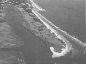
The following photograph shows the location of Sea Island’s eight-lot development in relation to the current groin and the loss of beach south of that groin (the groin is at the very top of the photograph):

– 3 –
Dr. Jackson has calculated the rate of erosion on the areas downdrift (south) and updrift (north) of the current groin prior to the installation of the existing groin system and after its installation. For the downdrift side, his data show that the mean rate of erosion from 1869 to 1988 (shortly before the groin was constructed in 1990) was only 0.08 meters/year (or approximately 0.26 feet/year). However, from 1988 (shortly before the groin system was installed) to 2013, the mean rate of erosion was 3.02 meters/year (or 9.9 feet/year), more than a three-seven-fold increase in the rate of erosion. Id. Even comparing two shorter and more recent time periods illustrates a dramatic increase in erosional rates since the existing groin was installed. For example, the mean rate of erosion from 1933 to 1988 was .83 meters/year (or 2.7 feet/year) whereas from 1988 to 2013, the mean rate of erosion was 3.02 meters/year (or 9.9 feet/year), more than a 3.5-fold increase in the rate of erosion. Id. And, as noted above, from 1988 (shortly before the existing southern groin was installed) to 2013, the amount of erosion has been almost 248 feet. These numbers demonstrate that erosion has strikingly accelerated since the existing groin system was constructed. Moreover, sea level rise will only serve to increase the rate of erosion in this area.
In comparison, on the updrift side of the current groin, the mean erosion shoreline change rates prior to installation of the current groin were not dramatically different from the mean shoreline rates on the downdrift side. For example, from 1869 to 1988, the mean rate of shoreline change on the updrift side was -0.08 meters/year, and on the updrift side was 0.16 meters/year. However, after installation of the existing groin, the mean shoreline change rate on the downdrift side was -3.02 versus +1.78 on the updrift side, a significant difference. Id.
Dr. Jackson has also developed a map depicting in graphic form the historical shorelines within 1200 feet of either side of the existing groin from 1869 to 2013. See Jackson Report at p. 7, Figure 1. That map plainly shows a fairly linear shoreline prior to installation of the existing groin. However, after the groin was installed, the shoreline on the downdrift side of the groin has steadily receded at a remarkable rate as compared to the original shoreline on the updrift side of the groin before the groin was installed, even accounting for the expected accretion on the updrift side.
These substantial shoreline losses south of the existing groin are not surprising because the purpose of a groin is to contain sand on the updrift side of the groin. That is precisely why Sea Island desires to build a groin on the Spit. When sand is contained on the updrift side, it does not travel to the downdrift side. The result is that the area on the downdrift side of the groin is starved of sand. This dynamic is the primary reason why groins are regulated in all states.
The Army Corps of Engineers acknowledges the adverse effects of groins by describing them thusly: “Groins are probably the most misused and improperly designed of all coastal structures. . . . Over the course of some time interval, accretion causes a positive increase in beach width updrift of the groin. Conservation of sand mass therefore produces erosion and a decrease in beach width on the downdrift side of the groin.” See Army Corps of Engineers Coastal Engineering Manual at Part V, Chapter C, p. V-3-59 (2002) (emphasis added). Any reputable scientist will agree that this is the net effect of a groin. Indeed, the Corps’ opinion is shared by at least 26 other coastal scientists. See http://coastalcare.org/2009/02/the-negative-impacts-of-groins/.
Dr. Robert Young, a Professor of Geology at Western Carolina University, a licensed professional geologist, and Director of the Program for the Study of Developed Shorelines at Western Carolina University/Duke University, also agrees with this undeniable dynamic:
The existing south groin on Sea Island is a perfect example of the downdrift impact of a typical groin constructed on a barrier island shoreline. Since the groin’s construction in 1990, the south end of the barrier island has lost a significant volume of sand and the spit has retreated over 2000 feet. This dramatic loss has included the disappearance of beach, sand shoals, dunes and marsh.
See Dr. Young’s report, “An Analysis of the Potential Impacts of the Proposed Sea Island Groin and Beachfill Project” attached as Exhibit 3 at p. 1 (“Young Report”).
Dr. Young’s Report includes a series of digitized shorelines of the Spit compiled from aerial photographs that graphically illustrate the reversal of a 130-year trend of extension of the southern end of the Spit after the southern groin was installed on Sea Island. See Young Report, Figure 2 at p. 3. After growing for at least 130 years, the southern end of the Spit has lost over 2,000 feet since the existing groin was constructed. Id. at pp. 1-3. In Dr. Young’s expert opinion, the existing groins on Sea Island have played a significant role in causing the southern end of the Spit to recede. Id. at p. 3. In observing that the entire oceanfront shoreline downdrift from the existing southern-most groin also has retreated significantly after the southern groin was installed, Dr. Young concludes that “. . . the groin must be assumed to be entirely responsible for the rapid erosion of the beach along the oceanfront”and that “[a]other groin, as proposed in this project, will simply exacerbate the existing, rapid decline on the south end of the island.” Id.
Dr. Young’s conclusion, buttressed by Dr. Jackson’s data, regarding the adverse effects of groins is consistent with textbook coastal geology. As Dr. Young notes, Paul Komar, Professor Emeritus at the College of Oceanographic and Atmospheric Sciences, Oregon State University, has described the destructive effect of groins in his textbook used by most coastal engineering programs in the United States: “Groins and jetties have the same effect in damming the longshore sediment transport. The shoreline builds out on the updrift side and erodes in the downdrift direction.” See Young Report at p. 1.
Sea Island admits the dramatic rate of erosion on the Spit immediately south of its existing groin, yet states in its application that the proposed groin would have no similar adverse effect on the ability of the existing sand-sharing system to minimize storm-wave damage and erosion at other shoreline locations. See Application at pp. 1, 4. Sea Island makes this bald assertion with little scientific analysis or support. Moreover, the limited amount of analysis that Sea Island provides is based almost entirely upon 30-year-old data from the early 1980s compiled by Griffin and Henry (1984). See Application at pp. 8-9. Griffin and Henry, however, did not have the benefit of far more advanced computer technology and GIS information that is available today, including Dr. Jackson’s AMBUR technology. Instead, Griffin and Henry used maps of different scales that were reduced or dilated and traced manually. As noted in the comments from the Georgia DNR’s Nongame Conservation Section, although Griffin and Henry’s work was pioneering over 30 years ago, Griffin and Henry measured shoreline changes manually, relied on approximations made by hand, and did not have the ability to compensate for mapping errors. See Nongame Conservation Section Comments filed in response to Sea Island ‘s Application (“NCS Comments”). In contrast, Dr. Jackson’s AMBUR methodology, recognized and applied worldwide, uses computer mapping programs that result in substantially more accurate assessments of shoreline change that can then be used to assess the effects of shoreline engineering projects on erosion rates.(4)
Sea Island’s contention that its proposed groin will have no adverse effect on the rest of the Spit is simply not supportable. The contention is contrary to what leading scientists with the most current and sophisticated methods and data have concluded. The contention is contrary to what the Army Corps of Engineers has concluded. The contention flies in the face of all of the available evidence showing precisely the contrary result with regard to the current groin on Sea Island. Finally, the contention is contrary to all common sense given that the entire purpose of a groin is to keep the sand on the updrift side from traveling to the downdrift side.
Quite simply, it defies logic to say, as Sea Island does, that one can install a device that will hold all of the sand in one place and yet, at the same time, say that the sand will continue to feed the rest of the shoreline. If sand cannot freely move back and forth, certain areas will be deprived of sand. That is exactly what has happened to the Spit as a result of Sea Island’s current groin. And it is what will continue to happen for every groin that is built. Sea Island’s unsupported, conclusory assertion of no adverse impact is not entitled to any weight.(5)
3. Sea Island’s proposed groin could threaten East Beach on St. Simons Island.
After many years of erosion at East Beach on St. Simons Island, East Beach has been accreting over the past few years. Construction of an additional groin on the Sea Island Spit may disturb this process. As noted above, groins halt the natural processes of the sand-sharing system. Because a groin deprives downdrift areas of sand, the construction of one groin typically leads to the construction of another one further down the beach in order to contain the already reduced sand in that area and to protect the adjacent property from erosion caused or exacerbated by the adjacent groin.
The domino effect that one groin has in causing additional ones to be built is precisely what is happening here with Sea Island’s latest proposed groin. The current groin on Sea Island has greatly accelerated erosion on the downdrift side. Until recently, this was of no concern to anyone on Sea Island because there were no homes or other structures on the downdrift side.
Now, however, Sea Island is in the process of developing eight new lots. The value of those lots will be significantly less if prospective buyers are not offered protection from the dramatic rate of erosion that is occurring in that area -thus, the need for another groin.
As more and more sand is prevented from naturally migrating to the south by groins on Sea Island, East Beach on St. Simons Island (immediately adjacent to Gould’s Inlet at the southern end of the Spit) could be threatened with a reversal of current accretion and with destabilization of its rock revetment. Sea Island presents no valid, detailed scientific analysis in its application to show that there is no realistic threat to St. Simons. Its application should therefore be denied.
Footnotes
(4) Sea Island also relies on computations made by Olsen in 1988, but Olsen based those computations on the initial earlier data provided by Griffin and Henry. See Application at p. 8. Olsen ‘s computations therefore suffer from the same defects as the Griffin and Henry computations . Finally, Sea Island relies on the Oertel/Basco Report which self-servingly cites to unpublished , unreviewable data from Oertel. It i s more than disingenuous for Oertel to cite to himself in his own report without any way to verify his data.
(5) Sea Island’ s Attachment D to its Application prepared by George Oertel and David Basco confirms that the existing groins on Sea Island have retained at least 90% of the original volume of sand, thus confirming the sand starvation effect to downdrift areas of the shoreline. (See Appl ication, Attachm ent D at p. 17.)
4. Sea Island’s proposed groin would adversely affect wildlife and wildlife habitat on the Spit, including sea turtle and shorebird habitat.
All sea turtle species are listed as threatened or endangered under the Endangered Species Act and are protected under O.C.G.A. § 27-1-3 and Ga. Comp. R. & Regs. 391-4-10. Sea turtles use the area south of Sea Island’s proposed groin for nesting. Additionally , that area is categorized as critical habitat for the federally endangered and threatened Piping Plover species, and is used by a wide variety of shorebirds and seabirds including the federally threatened Red Knot. Gould’s Inlet, at the southern tip of the Spit, provides nesting habitat for two state species of concern, the American Oystercatcher and Least Tern, as well as migratory stop-over sites and winter roost sites for state species of concern, including the Whimbrel and Red Knot. As further discussed below, Sea Island’s proposed groin would result in a loss of sea turtle nesting habitat and would unreasonably interfere with the conservation of federally and state protected species, including the Loggerhead sea turtle, Piping Plovers, Least Tern, American Oystercatcher, Whimbrel, and Red Knot.
According to the Georgia DNR’s Nongame Conservation Section (“NCS”), shoreline engineering, including the existing two groins on Sea Island, has already resulted in the loss of significant nesting habitat for sea turtles on Sea Island. Indeed, according to the NCS, approximately 38% of the ocean shoreline is armored and unusable by turtles for nesting. See NCS Comments filed in response to Sea Island’s Application. As noted by the NCS, shoreline stabilization structures, such as groins, prevent sea turtles from accessing the dry sand beach to lay eggs and reproduce, and they also scour and accelerate erosion of habitat adjacent to the structures. Id. Additionally, such artificial devices inhibit the movement of nesting females to the beach, function as barriers to hatchling migration to the ocean, entrap hatchlings within the structure, and concentrate predators resulting in increasing hatchling mortality. Id. Habitat within 100 meters (or approximately 300 feet) of shoreline stabilization devices cannot be used by turtles because such areas are unstable, are more susceptible to tidal inundation or loss due to erosion, and provide the means for predators to ambush prey coming from off the beach. Id.
Consistent with the overwhelming consensus of objective scientists on this issue, NCS expects any new groin on Sea Island to increase the rate of erosion on the Spit. Id. NCS believes that the construction of the proposed T-groin will result in both the direct and indirect loss of sea turtle habitat. Id. The loss will be significant comprising approximately 240 meters (720 feet) of nesting beach habitat. Id.
Sea Island’s proposed groin is contrary to the “Recovery Plan for the Northwest Atlantic Population of the Loggerhead Sea Turtle” (NMFS/USFWS 2008). That Recovery Plan provides that maintaining the current length and quality of Loggerhead sea turtle nesting beach is a number one priority for recovery of this species (Action Number 231). Infact, the goal is to increase, not decrease, the percentage of available sea turtle nesting habitat. Sea Island’s proposed groin is also contrary to Georgia DNR’s “Management Plan for the Protection of Nesting Loggerhead Sea Turtle and Their Habitat in Georgia” which recommends that permits should not be issued for shoreline engineering devices parallel to the shore because (1) such devices may block access to nesting habitat and interfere with incubating eggs and hatchlings as they attempt to make their way to the sea and (2) such devices degrade or eliminate viable nesting habitat by blocking the dynamic sand sharing system. Sea Island ‘s proposed T-head groin is one such device, and, thus, the requested permit should be denied.
With respect to water birds, shorebirds and seabirds, those species require the natural sand-sharing system for nesting, roosting, and foraging. Although the proposed groin may not affect water bird and shorebird habitat within the confines of the Cloister Reserve, it will affect such habitat at the southern end of the Spit. As noted by Dr. Young, the existing groin system on Sea Island has led to the loss of over 2,000 feet at the southern end of the Spit, an area that includes critical habitat for both the endangered and threatened Piping Plovers. Furthermore, in addition to the Piping Plover, the Red Knot, American Oystercatcher , Whimbrel, and Least Tern rely on the southern end of the Spit for nesting, roosting, and foraging. Shoreline engineering devices, including groins, constitute a major threat to shorebird conservation because they disrupt the natural sand-sharing system. See Atlantic Flyway Shorebird Business Plan (2015).
Sea Island attempts to minimize the impact of its destructive groin project on sea turtles by suggesting that the project area will increase sea turtle habitat by increasing the beach area in front of the Cloister Reserve. However, as documented by the NCS, Loggerhead sea turtles already use the entire proposed project area for nesting at densities similar to other Georgia beaches with the exception of a small section of beach immediately south of the existing groin where rock armoring associated with an access road restricts the use of the dry sand beach. See NCS Comments at p. 1. Sea Island’s proposed groin and access area will create another section of beach that will not be available for sea turtle nesting. Additionally, greater human activity associated with the Cloister Reserve will likely reduce the ability of sea turtles to use the project area for nesting. The net effect of the project will therefore be to reduce the amount and quality of sea turtle nesting habitat on the Spit.
With respect to bird species, Sea Island acknowledges that its “proposed project has the potential to affect Piping Plover critical wintering habitat in Unit GA-14 . . . .”and “within the proposed project area,” but attempts to discount these potential effects on the grounds that the project area is currently a beach access point with high levels of disturbance, the site has little to no beach above the high water mark, and the site has a narrow beach backed by high vegetation covered dunes that are less favored by plovers. See Application at Attachment F, pp. 20-21.
Even if these three factors are true, they in no way address the effects that the proposed project will undeniably have on the southern end of the Spit -the very area that Sea Island contends is used more frequently by Piping Plovers.
Sea Island’s only other basis for discounting adverse effects on bird species and their habitat is to rely on a bird survey by Normandeau Associates. That survey, however, was too limited in scope to form any reliable basis for evaluating impacts of the proposed project on bird species. For example, the survey took place only during the spring migratory season and terminated before the migration was complete. In fact, the survey itself shows that the numbers of Red Knots were still increasing at the time the survey ended, May 8. Both Semi-Palmated Sandpiper and Red Knot migratory numbers have been found to peak after May 8 in Georgia. Thus, not only did the survey take place during only one migratory season, it was not even for the full term of that season. Additionally, no night surveying was conducted, utterly missing the Whimbrel, which form big staging flocks at Gould’s Inlet before continuing their migration north. These flocks come together at dusk and move on at dawn, negating the possibility of an inclusive and exhaustive survey without evening surveys being conducted.
The lack of surveying during the breeding season for all of these species, arguably one of the most important times for increasing species population numbers, makes this survey grossly incomplete. Shorebirds often take a different fall migration route than their spring migration route, indicating that surveying during only one of these migration periods is presenting only half of the migratory picture. Many species, including the endangered Piping Plover utilize Georgia’s coast as their wintering grounds, and they were not surveyed at all during the winter. As no breeding, fall migratory, and winter surveys were conducted, the survey presented by Sea Island represents a grossly inaccurate and incomplete picture of how shorebirds utilize Sea Island and Gould’s inlet, therefore negating an understanding on how this T-groin might impact water, shore, and seabirds.
Experts in the Nongame Conservation Section of the Georgia DNR whose lives are devoted to studying the species at issue in Georgia are far more knowledgeable about the potential adverse impacts of Sea Island’s proposed groin on those species than persons from other states who performed short-term, limited, one-time surveys. The NCS experts have carefully studied Sea Island’s proposed groin, have filed thorough comments regarding that proposal, and have unequivocally concluded that the proposed groin would have a significant adverse impact on federally protected sea turtles and waterbirds in violation of state and federal law, the “Recovery Plan for the Northwest Atlantic Population of the Loggerhead Sea Turtle”, and DNR’s “Management Planfor the Protection of Nesting Loggerhead Sea Turtle and Their Habitat in Georgia.” As a result, Sea Island ‘s application should be denied.
5. Sea Island has not met its statutory burden to show that there is no reasonable or viable alternative to its proposed shoreline engineering device in violation of O.C.G.A. § 12-5-239(c)(3).
Georgia’s Shore Protection Act provides that “[a] permit for shoreline engineering activity or for a land alteration on beaches, sand dunes, and submerged lands may be issued only when:
- A. The activities associated with the construction of the proposed project are to be temporary in nature, and the completed project will result in complete restoration of any beaches, dunes, or shoreline areas altered as a result of that activity;
- B. The proposed project will insofar as possible minimize effects to the sand sharing mechanisms from storm-wave damage and erosion both to the subject parcel and at other shoreline locations;
- C. In the event that shoreline stabilization is necessary, either low-sloping porous rock structures or other techniques which maximize the dissipation of wave energy and minimize shoreline erosion shall be Permits may be granted for shoreline stabilization activities when the applicant has demonstrated that no reasonable or viable alternative exists; provided, however, that beach restoration and renourishment techniques are preferable to the construction of shoreline stabilization activities; and
D. A copy of the permit application has been transmitted to the local unit of government wherein the project site lies, if such local unit of government has been certified by’the board, requesting comments on such application.”
O.C.G.A. § 12-5-239(c)(3) (emphasis added). As the language of this statutory provision makes clear, all four conditions must be met before a permit may be issued for a shoreline engineering activity or for land alteration on beaches, sand dunes, and submerged lands.
Sea Island’s application does not comply with the requirements of O.C.G.A. § 12-5- 239(c)(3). First, the proposed project will not result in complete restoration of the shoreline areas as required by subsection (c)(3)(A). The proposed groin would be 350 feet long, six feet tall, and six feet wide. It will have a 120-foot long T-head at the end of it parallel to the shoreline. It will involve the permanent layering of rock on the sea bottom. And it will have a 200-foot layer of rock at the landward end of the groin to allow access for maintenance. See Application at p. 2. As such, the groin project will permanently alter portions of the shoreline. Such permanent alteration cannot possibly include “complete restoration” as required by the statute.
Second, the proposed project would not minimize as much as possible effects to the sand sharing mechanisms from storm-wave damage and erosion at other shoreline locations as required by subsection (c)(3)(B). As discussed previously in some detail in these comments, the proposed project would result in significant erosion to the immediate south/downdrift side of the groin and to the southern tip of the Spit. Those adverse effects will be exacerbated by the T-head at the oceanward end of the groin. The purpose of the T-head is to further inhibit the movement of sand around the end of the groin to the southern portion of the Spit in order to retain that sand for the beach in front of the Cloister Reserve. T-heads can be very effective at disrupting the natural sand-sharing system as aptly demonstrated by the T-head on the existing southern groin. Alternatives such as a beach nourishment project without a groin and T-head would minimize as much as possible any adverse effects to the sand-sharing mechanisms. (6)
Third, the proposed project is not necessary, and Sea Island has failed to demonstrate that other reasonable or viable alternatives do not exist, such as beach restoration and renourishment without a groin, as required by subsection (c)(3)(C). As noted previously, the groin project is being proposed to accompany an eight-lot development known as the Cloister Reserve. No homes or other structures have been built that would require protection from a groin. In fact, there is nothing in the proposed area at this point in time that requires any real protection. There is no guarantee that anything will ever be built at the Cloister Reserve and until that time comes, there is no need for any shoreline protection device or shoreline restoration of any kind.
Not only is there nothing that requires any protection in the proposed project area, the location of the unbuilt eight-lot development has been classified as unsafe and unstable . The United States Department of the Interior has classified the Spit, including the area encompassed by the Cloister Reserve, as N04 under the Coastal Barrier Resources Act (“CBRA”). This classification makes any development on the Spit ineligible for federal flood insurance or federal disaster assistance. The purposes of the CBRA are to preserve the ecological integrity of areas that serve to buffer the mainland from storms, to provide important habitat for fish and wildlife, and to discourage development in highly flood-prone areas. See 6 U.S.C. § 3501 et seq. Sea Island ‘s anticipated eight-lot development is contrary to the purposes of the CBRA and is unsafe and foolhardy. A groin to protect such a dangerous development should not be permitted, particularly when it will adversely affect the rest of the Spit and the endangered species that rely on it.
Apart from the Cloister Reserve’s ineligibility for federal flood insurance, subsection (c)(3)(C) plainly provides that no shoreline stabilization activities, such as the proposed groin, are permitted unless other reasonable or viable alternatives do not exist. At least one such alternative does exist -a beach nourishment project without a groin. See Young Report at p. 4. As pointed out by Dr. Young, such a project would serve to mitigate for damage already caused by the existing groin and would be a much less damaging option to the construction of another groin along this shoreline. Id. Indeed, Dr. Young has concluded that the cumulative impact of adding another groin could be “catastrophic” because the end of the island is already retreating rapidly, it is more likely than not that another groin would increase this rate of retreat and associated habitat loss, and it might be only a few years before the foundation of the groin itself would be threatened. Id.
Subsection (c)(3)(C) also plainly provides that beach restoration and renourishment techniques are preferable to the construction of shoreline stabilization activities such as groins. Sea Island has not made any showing that beach nourishment without a groin is not a reasonable or viable alternative. Its application must therefore be denied.
In evaluating compliance with subsection (c), the statute sets forth several assessment tools and techniques that should be considered. See O.C.G.A. § 12-5-239(d). Those factors include, without limitation, historic photographs, any recognized or accepted scientific investigations necessary to determine the proposed project’s impacts on surrounding biological and geological systems, the potential effects of groins on the sand-sharing system, possible potential effects of the proposed project on erosion and accretion rates, and new scientific information which, through recent advances, would effect a more competent decision relative to wise use and management of Georgia’s sand-sharing system. Id.
The data submitted by Drs. Young and Jackson relies upon all of the above tools and techniques, particularly historic aerial photographs and new scientific information which has been developed through Dr. Jackson’s recent advances in the development and use of AMBUR. These two coastal geology experts are in the vanguard of evaluating forces that affect erosion and accretion on coastal shorelines, including artificial shore engineering devices such as groins. They have both concluded that Sea Island ‘s proposed groin will have adverse effects on the sand-sharing system and coastal wildlife. Dr. Young’s and Dr. Jackson’s modem, advanced, computerized data and methodology , and the inescapable conclusions drawn therefrom, easily trump the 30-year-old less reliable and less accurate data and methodology from Griffin and Henry relied upon by Sea Island in its application. Again, Sea Island’s application should be denied.
Footnotes
(6) A groin without a T-head would also cause less disruption to the sand-sharing system, but such a device should not be allowed because, in accordance with subsection (c)(3)(C), other reasonable or viable alternatives such as beach restoration and renourishment exist.
6. Sea Island’s proposed groin is not in the public interest.
The Shore Protection Act requires that a proposed shore engineering device be inthe public interest. See O.C.G.A. § 12-5-239(i). The Act sets forth three factors to be considered in evaluating the public interest:
- whether the device will create unreasonably harmful, increased alteration of the dynamic dune field or submerged lands, or the function of the sand-sharing system;
- whether the completion of the applicant’s proposal will unreasonably interfere with the conservation of marine life, wildlife, or other resources; and
- whether the completion of the applicant’s proposal will unreasonably interfere with the reasonable access by and recreational use and enjoyment of public properties impacted by the
Consideration of all three factors mandates a finding that Sea Island’s proposed groin is not in the public interest. First, these comments have demonstrated convincingly that the proposed groin will impede the normal function of the sand-sharing system along the Spit’s shoreline. In fact, that is the function of a groin -to prevent sand from traveling in normal fashion along the shoreline. An objective and current evaluation of the effect of the existing groin through the use of more current data and more advanced technology shows that the current groin system on Sea Island has already caused substantial damage and erosion to the shoreline south of the groin. As Dr. Young has noted, another groin will only exacerbate that damage with potential catastrophic results.
Second, these comments have extensively discussed the adverse effects that another groin will have on the conservation of endangered/threatened sea turtles, shorebirds, and waterbirds and their critical habitat. The existing groin on Sea Island has already adversely affected sea turtle nesting habitat and resulted in the loss of habitat at the southern tip of the Spit. The harmful effects of another groin will be no different.
Third, although Sea Island is a private island, its immediate surroundings which include Gould’s Inlet and the areas below mean high tide, are public property and are beloved by wildlife enthusiasts. Gould’s Inlet and the Spit in general are a birder’s paradise. The sand shoals and mud flats created, in part, by the sand-sharing system at the southern tip of the Spit and in
Gould’s Inlet have resulted in that area being one of the top bird watching locations in the southeast. Approximately 144 species of birds occupy this area at some point during the year. Groins interfere with the sand-sharing system that makes all of this possible. As noted previously, the existing groin has already contributed to the loss of over 2000 feet at the end of the Spit resulting in loss of wildlife habitat. The proposed groin will certainly contribute to loss of recreational use and enjoyment of this unique area.
The proposed groin is not in the public interest. In fact, the only interest it serves is the private interest of Sea Island to make millions of dollars on the sale of lots that likely cannot be sold without an artificial and destructive shoreline engineering project such as the one being proposed here. Sea Island’s application should be denied.
7. Sea Island’s permit application is devoid of any real engineering or scientific analysis.
Sea Island’s permit application stunningly contains little, if any, engineering or scientific analysis. For exan1ple, the application fails to provide any substantive analysis for the chosen length and design of the proposed groin, particularly as it relates to the benefits/impacts or benefits/costs. See Young Report at p. 4. The application likewise contains no substantive analysis regarding the degree that the project will reduce long-term coastal retreat, erosion, and storm surge flooding. Id. at pp. 4-5. It provides no indication regarding how long the project will last and whether, when and how often another beach nourishment will be required. Id. at p. 5. There is no analysis of the degree to which removing sand from the proposed borrow area may increase the hazard exposure to properties behind the borrow area. There is no analysis regarding whether the construction of a dune system will have an adverse effect on shorebirds that rely cm sand flats, such as overwash fans, and which provide prime habitat for many shorebirds including piping plovers. Id. There is no analysis of the degree to which the groin would reduce shorebird habitat through reduced longshore sediment transport. Id. at pp. 5-6. As noted above, there is no analysis of all viable and reasonable alternatives including a beach nourishment project without a groin.
As Dr. Young has noted, Sea Island’s application “is as thin of an engineering design document as [he] has ever seen.” Consequently , no informed decision on the impacts and efficacy of the project can be made based on the application. Id. at pp. 5-6.
8. Conclusion.
Two of the most respected and knowledgeable coastal geological experts have provided and analyzed the most current and technologically advanced data showing that Sea Island’s proposed groin will cause significant adverse effects to the sand-sharing system and to endangered species and critical habitat on the Sea Island Spit. Dr. Jackson literally invented AMBUR which is now used worldwide and, closer to home, in Georgia, North Carolina, South Carolina and Puerto Rico to evaluate and calculate shoreline change. He has mapped shoreline change data for the entire Georgia coast which is now available on the Georgia DNR’s Coastal Hazards Portal website.
The U.S. Army Corps of Engineers and classic coastal geological textbooks used throughout the United States confirm that groins produce adverse effects including erosion on their downdrift sides. Ors. Young and Jackson have confirmed this effect from the existing groin on Sea Island. Sea Island has not considered or shown why a beach nourishment project without a groin would not be a viable or reasonable alternative to its undeniably destructive groin proposal. Under the Shore Protection Act, Sea Island has the burden to show that such an alternative is not reasonable which it has failed to do. It has also failed to show that its proposal is in the public interest as opposed to its own private interest.
Given the demonstrably destructive effects of groins in general, and groins on Sea Island in particular, approval of this proposal will set a very bad precedent for the entire Georgia Coast. If this proposal is approved, it will be extremely difficult for the Shore Protection Committee to ever deny another such proposal. With sea level rise already occurring and projected to continue, the likelihood of an increasing number of such proposals is high. Thus, if this application is approved, the result will be a walling-in of Georgia’s entire coast. As one famous songwriter has written in a different context, “one thing leads to another.” More prescient words could not have been written to describe the effect that one groin has. For once there is one, there will always be a demand for another due to the downdrift erosional effects that groins have.
It is time to draw a line in the proverbial sand. Sea Island’s ill-advised groin proposal should be denied.
Respectfully submitted,
Steven D. Caley

There are so many ways that you can help keep our rivers clean and beautiful. Responding to Action Alerts or reaching out to your elected representatives. Find your way to get involved!